29 Jul Tatra Hikes: Rysy Peak – Between Slovakia and Poland
Probably when you are thinking about mountains in Slovakia one of the most visited in the country would certainly be the Rysy Peak hike. This is mostly due to the fact that it is one of the highest mountaintops you can reach in the High Tatras without a paid guide but also because it represents the highest peak in Poland and the ascension can be done from both countries.
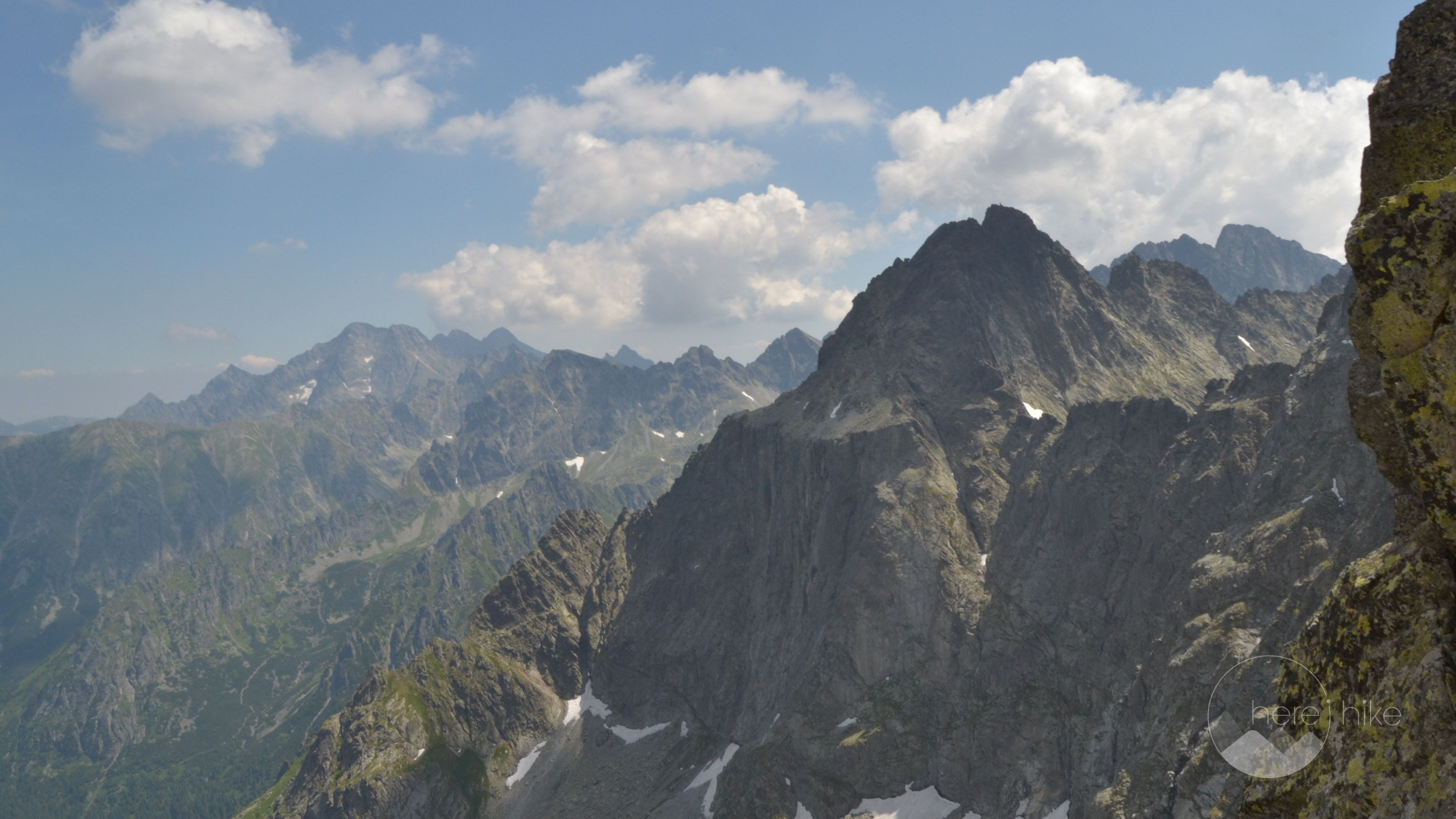
The Tatra mountain range is part of the Carpathians that also pass through Romania, but they are totally different, with high, rocky and sharp peaks that require a more technical approach. Don’t let that scare you as you will certainly find many tracks with a difficulty level scaling from easy to hard depending on the level and physical condition you are in. And hey, if you really want to experience the view from an altitude of over 2600 meters you can visit Lomnický Peak as the good Slovakian people have built a cable car that goes all the way to the top.
Distance
21 Km
Total Time
11 h 00 min
Active Time
8 h 42 min
Vertical Relief
+1300 / -1300 m
Min/Max Altitude
1210 – 2495 m
Average Speed
2.4 km/h
Hike to Rysy Peak
If you chose not to pay the parking place then from where you left the car you will have to walk 1.5 kilometres until the starting point of the Rysy Peak hike (you will pass next to a small train station). Cross over the railway and after approximately 50 meters do a right turn on the smaller road that heads up the mountain (the road is closed to autos and motorbikes).

From here you will walk approximately 4 kilometers on a small, narrow – paved road that leads up to Popradske Lake following the valley of the Poprad River. Just before the lake you will stand at a crossroads of tracks, exactly as you can see on Google Maps. From here you will need to go slightly left on the blue tape track 
You will follow the blue tape 
But just wait to see their color from above! This is amazing!
As an observation, the section to Rysmi is where it starts getting somewhat demanding as the altitude gain is more accentuated during the approximately 3.5-kilometre hike.
When you reach the chalet you will be in for a great surprise, on one hand you can enjoy a warm meal and a cold beer high up in the mountains and on the other hand you will reach one of the best toilet in the world! This thing is simply incredible as it is a one person cabin suspended between two rocks with the whole valley as a view and a glass front wall for you to enjoy the high mountaintops around! Make sure to bring a camera with you! You have to share this wonder with your friends!
The track to Rysy continues right in front of the chalet and climbs slowly to a small saddle from where the final ascent to the mountain top starts.
There is nothing extremely hard about this except for the final part, right under the peak, where you will encounter a stiff cliff full of gravel and rock. As if this wasn’t enough there will be a ton of people hanging around on the peak, eating their lunch or simply resting, and you will have to be extra careful to avoid them while also paying attention not to trip on the moving rocks. We managed to take only one photo of the peak as we wanted to let other folks claim this hard earned reward. I will say again, watch you step up there as it can get really crowded! One guy tripped and almost fell to his doom in the abyss below, stopping only by sheer luck on the last edge. Thankfully he was more or less OK and no emergency interventions were required.
For the return trip from the Rysy Peak hike, you will have to go on the same road back in order to reach your car. If you want you can also descend on the somewhat more technical polish side of the mountain. The only problem is that you will have to catch a ride back to your car.

There are many peaks and other interesting alpine tracks in the area but as we have previously specified you will need to check prior to departure if you are allowed to hike them without a permit or guide. Here is a pretty detailed map of the High Tatras with all of the hikes, markings and timings included. Unfortunately, it is not a digital version but you should be able to get a good idea of where you need to go to in the High Tatras of Slovakia.
Here are some other destinations we went to:
- Slavkovský štít – 2452 meters
- Bystre saddle circuit – 2306 meters


GPS track to Rysy Peak
How to get to Rysy Peak?
Getting to Slovakia is pretty easy especially from Timisoara now that the Romania – Hungary highway is open. In total, we drove approximately 600 kilometres out of which 350 kilometres were on highways and it took us roughly 8 hours for the whole trip including coffee breaks. In Hungary, we drove on M43, M5, M0 and finally on M2 after detouring Budapest. We have entered Slovakia through Sahy and made our way north through Zvolen, Banská Bystrica and Štrba before reaching our final destination Tatranská Štrba. We chose to avoid highways in Slovakia as there are quite a few of them on this itinerary and it isn’t really worth it to pay the 10 euros (per 10 days) for the vignette.
To reach the starting point of the Rysy Peak hike from Tatranská Štrba we will go to Štrbské Pleso, a cosy mountain resort some 9.5 kilometers away, where we will leave the car at the small train station there for the price of 6 euros per day. If you choose to not pay for parking you can leave the car here, right before the bridge over the Poprad river, but you will have to walk one extra kilometre.
Where to sleep?
On our trip, we chose Autocamping Tatranská Štrba in Tatranská Strba as a base camp from where did all the hikes in the High Tatras. The place is pleasant and the prices are fair, summing up at 15 euros per two persons, tent and car per night. The toilet facilities could be cleaner but at least they have hot water at the showers and sinks. Other than this, the camping is ideally located with many hikes routes at 10 to 20 kilometers away.They even have a playground for small children and you can park you car next to the tent. The camping has a common kitchen with stoves, plates, glasses, silverware, a fridge you can use and there are many places you can sit and enjoy your own food if you bring it with you. If you would like to have a barbecue there is a grill available but I am not sure if they offer firewood or if you have to bring/buy your own. There are a lot of other accommodations in the area with prices from really cheap to expensive, depending on your personal needs and budget, but in terms of campings the offer is low and we found this one to have the best location for our needs.

Good to know
You can eat whatever you bring with you or you can try out the restaurant that is on the camping grounds. I really recommend the place as the prices are really good and the food is extraordinary, especially the vegetarian and traditional Slovak dishes. A main meal is somewhere at about 3-4 euro, the soup is around 1 euro and a beer is 1.1 – 1.2 euro. Usually, we had dinner here and payed for two persons something like 10-13 euro with drinks included. I also recommend Tatra Tea, a traditional Slovakian herbal liqueur that comes with many flavors and alcohol concentrations varying from 22% up to 72%. If you would like to try some other eating place you can rest assured as there are many options close by.
- Before planning a mountain trip in Slovakia search what peaks are open for visiting and don’t require a mandatory mountain guide. For example the highest peak, Gerlachovský, is closed to visitors and you require either a professional mountain guide or to be part of some hiking club with prior approvals from the Tatra Park officials. There are other high peaks that fall under the same rules. Find more info on the Tatra National Park Official Site.
- Wild camping is strictly prohibited in the Tatra Park and you risk a high fine if you are caught. Same thing applies for littering, bathing in glacial lakes, building a campfire or picking flowers.
- In general, but mostly in Slovakia, pay close attention to traffic rules and watch you speed as there is a lot of police on the road. You will find speed radars everywhere and especially in resorts where the police tend to be located either at one end or the other of the village/town. If you feel the need for speed you risk a really high fine as recently they have been increased and are close to the ones in Austria or Switzerland.
- In contrast to some other European countries, you should know that the alcohol tolerance in Slovakia is 0% so don’t even think you can get by with a beer on board.
- Pack plenty of water with you while hiking the High Tatras as there are not many water sources on route. During the summer months, some of the water springs might dry up and you don’t want to get caught with no liquids high up in the mountains.
There is no entrance fee for the Tatra National Park but almost at the start of each hiking track there will be a paid parking lot. Some of them can be avoided, but some cannot. The prices are usually between 5 and 10 euros per day.


Hope you found the information helpful and accurate, but remember, if you have any questions drop them in a comment below!
Other great adventures
-
Transylvania MTB Ride: Sirnea
If you’re planning to visit Transylvania, particularly Brasov area and you’re also looking forward to some beautiful mountain biking routes, we totally recommend this one. A nice 50 km ride will enter...
-
Cycling around Dracula’s Castle – Piatra Craiului National Park
Dracula's Castle, an international landmark, is probably one of the most visited places in Romania but we are not going to talk about that. Nevertheless, we are going to talk about the cycling opport...
-
Italian Dolomites: Via Ferrata Giovanni Lipella (4C)
Via ferrata Giovanni Lipella is one of the most emblematic routes in the Dolomites. Not only are the views breathtaking but also the ferrata is a bit more challenging due to its length, altitude and e...
Ruth
Posted at 02:21h, 19 AugustAnother great hike! I LOVE that toilet.
http://www.travelwithkevinandruth.com
Karina
Posted at 09:16h, 19 AugustTell me about it! Best ever! 🙂
RakaTravel Zakopane
Posted at 21:27h, 12 AprilGreat article, we also love this hike <3
Karina Isar
Posted at 09:13h, 13 AprilThank you! It was amazing and I'd return for the peak and definitely for the toilette! 🙂 Tatras are a wonderful piece of work!
Unknown
Posted at 22:33h, 23 JulyVideo from area: https://www.youtube.com/watch?v=9kVBij356lQ
Karina Isar
Posted at 10:19h, 02 AugustThanks for sharing! All the best! 🙂